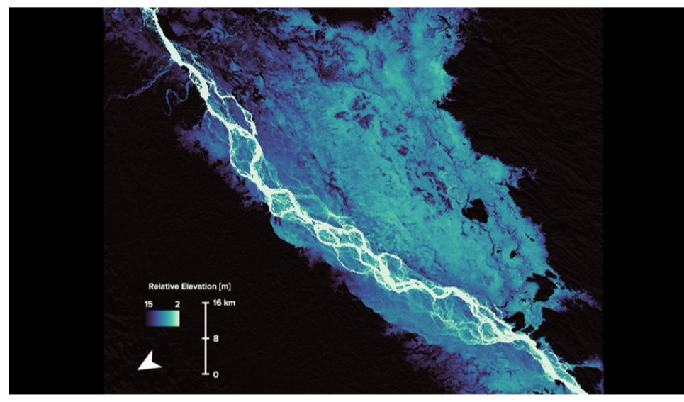
Researchers studied the channel belts of the Brahmaputra River as part of new research cataloging global rivers. Photograph by Tian Dong..
By Joel Goldberg..
27th. July 2022.
A new method shows a key relationship between the width and makeup of Earth’s river channels over time. The technique could be applied to other terrestrial bodies, such as Mars.
The violent floods that tore through Yellowstone National Park last month—leveling riverside structures and hurling debris left and right—put into sharp relief the impact that river paths have on ecosystems and human lives. By understanding rivers’ shifting courses over thousands and even millions of years, we can draw insights into past environments and better predict what they may be like in the future.
Now, scientists have developed a new approach based on satellite data that makes the study of Earth’s ancient river channels more precise and may even teach us about primordial Mars.
The technique focuses on the nature and evolution of channel belts, grooves in Earth’s surface molded by the mercurial movements of rivers over time. Two types of rivers forge these belts. One is single-channel rivers, which flow as a united, meandering mass, paving wide channel belts as they migrate and pile sediments around their banks. The lower Mississippi River is a single-channel river.
Multichannel rivers also form channel belts. Multichannel rivers are braided networks of river channels that bounce across the landscape in a game of geological hopscotch. A prime example of a multichannel river is the Brahmaputra River, which skips its way from the Himalayas down to the Bay of Bengal.
Tian Dong, an Earth sciences postdoctoral fellow at the University of Texas at Austin and lead author of the new study, hopes this approach focusing on channel belts will help create a far-reaching catalog of rivers.
Looking into Earth’s Past from Space.
Traditionally, geologists must get up close and personal to understand the histories of channel belts, examining rock outcrops in meticulous detail to get a sense of where rivers once flowed. The study of channel belts has expanded from vertical, to lateral, to aerial, said Ben Cardenas, an assistant professor of geosciences at Pennsylvania State University. Cardenas has worked on both traditional outcrop studies as well as those based on images from drones and satellites but was not involved in the new research.
“You look at which rocks are on top of which rocks, and you describe the changes in those rocks,” said Cardenas, describing the “classical” vertical study of river evolution. “That [method of study] evolved over time to also looking laterally.”
The new research draws on freely available NASA and European Space Agency satellite data, taking an astronaut’s-eye view of channel belts. “Here we’re in, like, the full, three-dimensional evolution, where we can look on top [of rivers], as well,” Cardenas said.
Satellite imagery can paint more complete pictures of rivers’ histories because there are a limited number of locations accessible to field researchers. Aerial views open the floodgates to studying harder-to-reach areas.
The new study was published in Geology in June.
Incorporating measurements from the satellite data, Dong’s approach assigned specific “channel numbers” to different channel belts. Channel numbers were determined by using what’s called the entropic braiding index, which classifies channels on the basis of the amount of water and sediment they discharge.
After normalizing for river size, Dong and coauthor Timothy Goudge found that typically, as channel number increased, the width of the channel belt decreased. One exception is confined rivers, which are blocked from freely migrating across the landscape by large formations, Dong said. The Grand Canyon makes the Colorado a confined river, he explained.
“It kind of changes how we think about how a river interacts with its flood plain,” Dong said. Because multichannel rivers tend to move across flood plains in wide networks, Dong believes they could be more likely than single-channel rivers to spread organic carbon. This possibility would change the overall carbon cycle over different periods in Earth’s history, as microorganisms in oceans would receive more or less nutrients to gobble up and release as carbon dioxide.
The research also suggests that single-channel rivers change landscapes more quickly as they expand in one direction or another, according to Cardenas.
In addition to magnifying our view of Earth’s ancient environments, Cardenas believes the research could help scientists explore the climatic evolution of other terrestrial worlds, such as Mars or Saturn’s moon Titan.
However, more work may be needed before this method could be applied to Mars or other worlds, said Francesco Salese, an associate researcher at the European Research Council who has researched fluid channels on Mars using satellite data but was not involved in the new study.
“Exactly distinguishing the channel from its channel belt is already challenging on Earth, where you can go and check for yourself the outcrop or the morphology in the field,” Salese explained by email. Doing such an analysis on Mars, where only satellite data are available, he said, would be very difficult and subject to large margins of error. However, Salese said, Dong and Goudge’s analyses “allow the scientific community to discuss precisely this aspect in the future in an even more detailed way.”
Joel Goldberg., Science Writer.
Citation: Goldberg, J. (2022), Satellite images reveal a new view of ancient Earth’s rivers, Eos, 103,
Published on 27 July 2022.
Courtesy, Eos.