
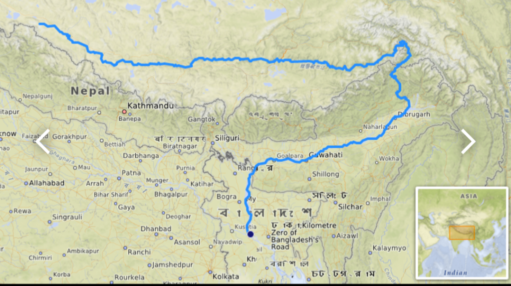
The Brahmaputra (/ˌbrɑːməˈpuːtrə/), also known as the Yarlung Tsangpo in Tibet, the Siang/Dihang River in Arunachal Pradesh, Luit in Assamese, and Jamuna River in Bangladesh, is a trans-boundary river which flows through Tibet, India, and Bangladesh. It is the 9th largest river in the world by discharge, and the 15th longest.
With its origin in the Manasarovar Lake region, near Mount Kailash, on the northern side of the Himalayas in Burang County of Tibet where it is known as the Yarlung Tsangpo River, it flows along southern Tibet to break through the Himalayas in great gorges (including the Yarlung Tsangpo Grand Canyon) and into Arunachal Pradesh.
It flows southwest through the Assam Valley as the Brahmaputra and south through Bangladesh as the Jamuna (not to be confused with the Yamuna of India). In the vast Ganges Delta, it merges with the Ganges, popularly known as the Padma in Bangladesh, and becomes the Meghna and ultimately empties into the Bay of Bengal.
About 3,969 km (2,466 mi) long, the Brahmaputra is an important river for irrigation and transportation in the region. The average depth of the river is 30 m (100 ft) and its maximum depth is 135 m (440 ft) (at Sadiya).[6] The river is prone to catastrophic flooding in the spring when the Himalayan snow melts. The average discharge of the river is about 19,800 m3/s (700,000 cu ft/s),[4] and floods reach about 100,000 m3/s (3,500,000 cu ft/s).
It is a classic example of a braided river and is highly susceptible to channel migration and avulsion.[8] It is also one of the few rivers in the world that exhibits a tidal bore. It is navigable for most of its length.
The river drains the Himalayas east of the Indo-Nepal border, south-central portion of the Tibetan plateau above the Ganga basin, south-eastern portion of Tibet, the Patkai hills, the northern slopes of the Meghalaya hills, the Assam plains, and the northern portion of Bangladesh. The basin, especially south of Tibet, is characterized by high levels of rainfall.
Kangchenjunga (8,586 m) is the only peak above 8,000 m and hence is the highest point within the Brahmaputra basin.
The Brahmaputra’s upper course was long unknown, and its identity with the Yarlung Tsangpo was only established by exploration in 1884–86. The river is often called the Tsangpo-Brahmaputra river.
The lower reaches are sacred to Hindus. While most rivers on the Indian subcontinent have female names, this river has a rare male name. Brahmaputra means “son of Brahma” in Sanskrit.
Names.
It is known by various names in different regional languages: Brôhmôputrô in Assamese; Tibetan: ཡར་ཀླུངས་གཙང་པོ་, Wylie: yar klung gtsang po Yarlung Tsangpo; simplified Chinese: 布拉马普特拉河; traditional Chinese: 布拉馬普特拉河; pinyin: Bùlāmǎpǔtèlā Hé. It is also called Tsangpo-Brahmaputra and red river of India (when referring to the whole river including the stretch within the Tibet Autonomous Region).

Yarlung Tsangpo River in Tibet. Photo taken by (Luca Galuzzi) http://www.galuzzi.it
GEOGRAPHY.
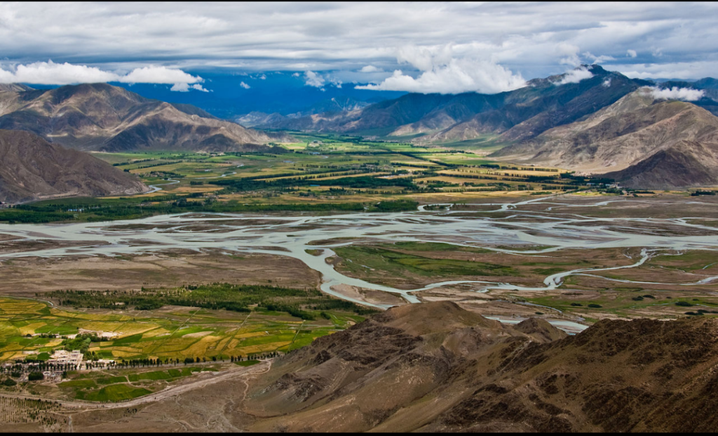
The upper reaches of the Brahmaputra River, known as the Yarlung Tsangpo from the Tibetan language, originates on the Angsi Glacier, near Mount Kailash, located on the northern side of the Himalayas in Burang County of Tibet.
The source of the river was earlier thought to be on the Chemayungdung glacier, which covers the slopes of the Himalayas about 97 km (60 mi) southeast of Lake Manasarovar in southwestern Tibet.
The river is 3,969 km (2,466 mi) long, and its drainage area is 712,035 km2 (274,918 sq mi) according to the new findings, while previous documents showed its length varied from 2,916 km (1,812 mi) to 3,364 km (2,090 mi) and its drainage area between 520,000 and 1.73 million km2.
From its source, the river runs for nearly 1,100 km (680 mi) in a generally easterly direction between the main range of the Himalayas to the south and the Kailas Range to the north.
Source, Own work. Author, Antoine Taveneaux.
In Tibet, the Tsangpo receives a number of tributaries.
The most important left-bank tributaries are the Raka Zangbo (Raka Tsangpo), which joins the river west of Xigazê (Shigatse), and the Lhasa (Kyi), which flows past the Tibetan capital of Lhasa and joins the Tsangpo at Qüxü. The Nyang River joins the Tsangpo from the north at Zela (Tsela Dzong). On the right bank, a second river called the Nyang Qu (Nyang Chu) meets the Tsangpo at Xigazê.
After passing Pi (Pe) in Tibet, the river turns suddenly to the north and northeast and cuts a course through a succession of great narrow gorges between the mountainous massifs of Gyala Peri and Namcha Barwa in a series of rapids and cascades.
Thereafter, the river turns south and southwest and flows through a deep gorge (the “Yarlung Tsangpo Grand Canyon”) across the eastern extremity of the Himalayas with canyon walls that extend upward for 5,000 m (16,000 ft) and more on each side. During that stretch, the river crosses the China-India line of actual control to enter northern Arunachal Pradesh, where it is known as the Dihang (or Siang) River, and turns more southerly.
India, Arunachal Pradesh State.
The Yarlung Tsangpo leaves the part of Tibet to enter Indian state of Arunachal Pradesh, where the river is called Siang. It makes a very rapid descent from its original height in Tibet and finally appears in the plains, where it is called Dihang.
It flows for about 35 km (22 mi) southward after which, it is joined by the Dibang River and the Lohit River at the head of the Assam Valley. Below the Lohit, the river is called Brahmaputra and Doima (mother of water) and Burlung-Buthur by native Bodo tribals, it then enters the state of Assam, and becomes very wide—as wide as 20 km (12 mi) in parts of Assam.
The reason for such an unusual course and drastic change is that the river is antecedent to the Himalayas, meaning that it had existed before them and has entrenched itself since they started rising.
Assam State, India.
The Dihang, winding out of the mountains, turns towards the southeast and descends into a low-lying basin as it enters northeastern Assam state.
Just west of the town of Sadiya, the river again turns to the southwest and is joined by two mountain streams, the Lohit, and the Dibang. Below that confluence, about 1,450 km (900 mi) from the Bay of Bengal, the river becomes known conventionally as the Brahmaputra (“Son of Brahma”). In Assam, the river is mighty, even in the dry season, and during the rains, its banks are more than 8 km (5.0 mi) apart. As the river follows its braided 700 km (430 mi) course through the valley, it receives several rapidly flowing Himalayan streams, including the Subansiri, Kameng, Bhareli, Dhansiri, Manas, Champamati, Saralbhanga, and Sankosh Rivers.
The main tributaries from the hills and from the plateau to the south are the Burhi Dihing, the Disang, the Dikhu, and the Kopili.
Between Dibrugarh and Lakhimpur Districts, the river divides into two channels—the northern Kherkutia channel and the southern Brahmaputra channel. The two channels join again about 100 km (62 mi) downstream, forming the Majuli island, which is the largest river island in the world.
At Guwahati, near the ancient pilgrimage centre of Hajo, the Brahmaputra cuts through the rocks of the Shillong Plateau, and is at its narrowest at 1 km (1,100 yd) bank-to-bank. The terrain of this area made it logistically ideal for the Battle of Saraighat, the military confrontation between the Mughal Empire and the Ahom Kingdom in March 1671. The first combined railroad/roadway bridge across the Brahmaputra was constructed at Saraighat. It was opened to traffic in April 1962.
The environment of the Brahmaputra floodplains in Assam have been described as the Brahmaputra Valley semi-evergreen forests ecoregion.
Bangladesh.
In Bangladesh, the Brahmaputra is joined by the Teesta River (or Tista), one of its largest tributaries.
Below the Tista, the Brahmaputra splits into two distributary branches. The western branch, which contains the majority of the river’s flow, continues due south as the Jamuna (Jomuna) to merge with the lower Ganga, called the Padma River (Pôdda). The eastern branch, formerly the larger, but now much smaller, is called the lower or Old Brahmaputra (Brommoputro). It curves southeast to join the Meghna River near Dhaka. The Padma and Meghna converge near Chandpur and flow out into the Bay of Bengal. This final part of the river is called Meghna.
The Brahmaputra enters the plains of Bangladesh after turning south around the Garo Hills below Dhuburi, India. After flowing past Chilmari, Bangladesh, it is joined on its right bank by the Tista River and then follows a 240 km (150-mi) course due south as the Jamuna River. (South of Gaibanda, the Old Brahmaputra leaves the left bank of the mainstream and flows past Jamalpur and Mymensingh to join the Meghna River at Bhairab Bazar.) Before its confluence with the Ganga, the Jamuna receives the combined waters of the Baral, Atrai, and Hurasagar Rivers on its right bank and becomes the point of departure of the large Dhaleswari River on its left bank. A tributary of the Dhaleswari, the Buriganga (“Old Ganga”), flows past Dhaka, the capital of Bangladesh, and joins the Meghna River above Munshiganj.
The Jamuna joins with the Ganga north of Goalundo Ghat, below which, as the Padma, their combined waters flow to the southeast for a distance of about 120 km (75 mi). After several smaller channels branch off to feed the Ganga-Brahmaputra delta to the south, the main body of the Padma reaches its confluence with the Meghna River near Chandpur and then enters the Bay of Bengal through the Meghna estuary and lesser channels flowing through the delta. The growth of the Ganga-Brahmaputra Delta is dominated by tidal processes.
The Ganga Delta, fed by the waters of numerous rivers, including the Ganga and Brahmaputra, is 59,570 square kilometres (23,000 sq mi), one of the largest river deltas in the world.
Basin characteristics.

The Brahmaputra River from Space. Author, NASA.
The basin of the Brahmaputra river is 651 334 km2 and it is a good example of a braided river and meanders quite a bit and frequently forms temporary sand bars. A region of significant tectonic activity has developed in the Jamuna River and is associated with the Himalayan uplift and development of the Bengal foredeep. Several researchers have hypothesized that the underlying structural control on the location of the major river systems of Bangladesh.
A zone of ‘structural weakness’ along the present course of the Ganga-Jamuna-Padma Rivers due to either a subsiding trough or a fault at depth has been observed by Morgan and McIntire. (1959). Scijmonsbergen (1999) contends that width changes in the Jamuna may respond to these faults and they may also cause increased sedimentation upstream of the fault. He presented a few images to argue that a fault downstream of the Bangabandhu Multipurpose Bridge has affected channel migration.
Huge accumulations of sediment that have been fed from Himalayan erosion has been produced due to the deepening of the Bengal Basin, with the thickness of sediment above the Precambrian basement increasing from a few hundred meters in the shelf region to over 18 km in the Bengal foredeep to the south. The tectonic and climatic context for the large water and sediment discharges in the rivers of Bangladesh was set by the ongoing subsidence in the Bengal Basin, combined with high rates of Himalayan uplift.
The control of uplift and subsidence is, however, clear. The courses of the Jamuna and Ganga Rivers are first-order controls due to the fact that they are most influenced by the uplifted Plcistoccnc terraces of the Barind and Madhupur tracts.
Climate.
Rising temperature is one of the major causes of snow-melting at the upper Brahmaputra catchment.[18] The discharge of the river Brahmaputra is highly affected by the melting of snow at the upper part of its catchment.
Then of river flow due to the melting of snow in the river Brahmaputra basin affects the downstream discharge of the river. This increase in discharge due to the significant retreat of snow gives rise to severe catastrophic problems such as flood and erosion.
Discharge.
The Brahmaputra River is characterized by its significant rates of sediment discharge, the large and variable flows, along with its rapid channel aggradations and accelerated rates of basin denudation. Over time, the deepening of the Bengal Basin caused by erosion will result in the increase in hydraulic radius, and hence allowing for the huge accumulation of sediments fed from the Himalayan erosion by efficient sediment transportation.
The thickness of the sediment accumulated above the Precambrian basement has increased over the years from a few hundred meters to over 18 km in the Bengal fore-deep to the south. The ongoing subsidence of the Bengal Basin and the high rate of Himalayan uplift continues to contribute to the large water and sediment discharges of fine sand and silt, with 1% clay, in the Brahmaputra River.
Climatic change plays a crucial role in affecting the basin hydrology.
Throughout the year, there is a significant rise in hydrograph, with a broad peak between July and September. The Brahmaputra River experiences two high-water seasons, one in early summer caused by snowmelt in the mountains, and one in late summer caused by runoff from monsoon rains. The river flow is strongly influenced by snow and ice melting of the glaciers, which are located mainly on the eastern Himalaya regions in the upstream parts of the basin.
The snow and glacier melt contribution to the total annual runoff is about 27%, while the annual rainfall contributes to about 1.9m and 19,830 m3 /s of discharge. The highest recorded daily discharge in the Brahmaputra at Pandu was 72,726 m3 /s August 1962 while the lowest was 1,757 m3 /s in February 1968. The increased rates of snow and glacial melt are likely to increase summer flows in some river systems for a few decades, followed by a reduction in flow as the glaciers disappear and snowfall diminishes. This is particularly true for the dry season when water availability is crucial for the irrigation systems.
Floodplain evolution.
The course of the Brahmaputra River has changed drastically in the past two and a half centuries, moving its river course westwards for a distance of about 80 km (50 mi), leaving its old river course, appropriately named the old Brahmaputra river, behind. In the past, the floodplain of the old river course had soils which were more properly formed compared to graded sediments on the operating Jamuna river.
This change of river course resulted in modifications to the soil-forming process, which include acidification, the breakdown of clays and buildup of organic matter, with the soils showing an increasing amount of biotic homogenization, mottling, the coating around Peds and maturing soil arrangement, shape and pattern. In the future, the consequences of local ground subsidence coupled with flood prevention propositions, for instance, localised breakwaters, that increase flood-plain water depths outside the water breakers, may alter the water levels of the floodplains.
Throughout the years, bars, scroll bars, and sand dunes are formed at the edge of the flood plain by deposition. The height difference of the channel topography is often not more than 1m-2m. Furthermore, flooding over the history of the river has caused the formation of river levees due to deposition from the overbank flow.
The height difference between the levee top and the surrounding floodplains is typically 1m along small channels and 2-3m along major channels. Crevasse splay, a sedimentary fluvial deposit which forms when a stream breaks its natural or artificial levees and deposits sediment on a floodplain, are often formed due to a breach in the levee, forming a lobe of sediments which progrades onto the adjacent floodplain. Lastly, flood basins are often formed between the levees of adjacent rivers.

During the monsoon season (June–October), floods are a very common occurrence. Deforestation in the Brahmaputra watershed has resulted in increased siltation levels, flash floods, and soil erosion in critical downstream habitat, such as the Kaziranga National Park in middle Assam.
Occasionally, massive flooding causes huge losses to crops, life, and property. Periodic flooding is a natural phenomenon which is ecologically important because it helps maintain the lowland grasslands and associated wildlife. Periodic floods also deposit fresh alluvium, replenishing the fertile soil of the Brahmaputra River Valley. Thus flooding, agriculture, and agricultural practices are closely connected.
The effects of flooding can be devastating and cause significant damage to crops and houses, serious bank erosive with consequent loss of homesteads, school and land, and loss of many lives, livestock, and fisheries. During the 1998 flood, over 70% of the land area of Bangladesh was inundated, affecting 31 million people and 1 million homesteads.
In the 1998 flood which had an unusually long duration from July to September, claimed 918 human lives and was responsible for damaging 16 00 and 6000 km of roads and embankments respectively, and affecting 6000 km2 of standing crops. The 2004 floods, over 25% of the population of Bangladesh or 36 million people, were affected by the floods; 800 lives were lost; 952 000 houses were destroyed and 1.4 million were badly damaged; 24 000 educational institutions were affected including the destruction of 1200 primary schools, 2 million governments and private tube wells were affected, over 3 million latrines were damaged or washed away, this increases the risks of waterborne diseases including diarrhea and cholera. Also, 1.1 M ha of the rice crop was submerged and lost before it could be harvested, with 7% of the yearly aus (early season) rice crop lost; 270 000 ha of grazing land was affected, 5600 livestock perished together with 254 00 poultry and 63 MT of lost fish production.
Flood-control measures are taken by the water resource department and the Brahmaputra Board, but until now the flood problem remains unsolved. At least a third of the land of Majuli Island has been eroded by the river. Recently, it is suggested that a highway protected by concrete mat along the river bank and excavation of the river bed can curb this menace.
This project, named the Brahmaputra River Restoration Project, is yet to be implemented by the government. Recently the Central Government approved the construction of Brahmaputra Express Highways.
Channel morphology.
The course of the Brahmaputra River has changed dramatically over the past 250 years, with evidence of large-scale avulsion, in the period 1776–1850, of 80 km from east of the Madhupur tract to the west of it. Prior to 1843, the Brahmaputra flowed within the channel now termed the “Old Brahmaputra”. The banks of the river are mostly weakly cohesive sand and silts, which usually erodes through large scale slab failure, where previously deposited materials undergo scour and bank erosion during flood periods. Presently, the river’s erosion rate has decreased to 30m per year as compared to 150m per year from 1973 to 1992. This erosion has, however, destroyed so much land that it has caused 0.7 million people to become homeless due to loss of land.
Several studies have discussed the reasons for the avulsion of the river into its present course, and have suggested a number of reasons including tectonic activity, switches in the upstream course of the Teesta River, the influence of increased discharge, catastrophic floods and river capture into an old river course. From an analysis of maps of the river between 1776 and 1843, it was concluded in a study that the river avulsion was more likely gradual than catastrophic and sudden, and may have been generated by bank erosion, perhaps around a large mid-channel bar, causing a diversion of the channel into the existing floodplain channel.
The Brahmaputra channel is governed by the peak and low flow periods during which its bed undergoes tremendous modification.
The Brahmaputra’s bank line migration is inconsistent with time. The Brahmaputra river bed has widened significantly since 1916 and appears to be shifting more towards the south than towards the north. Together with the contemporary slow migration of the river, the left bank is being eroded away faster than the right bank.
River engineering.
The Brahmaputra River experiences high levels of bank erosion (usually via slab failure) and channel migration caused by its strong current, lack of riverbank vegetation, and loose sand and silt which compose its banks.
It is thus difficult to build permanent structures on the river, and protective structures designed to limit the river’s erosional effects often face numerous issues during and after construction. In fact, a 2004 report[23] by the Bangladesh Disaster and Emergency Sub-Group (BDER) has stated that several of such protective systems have ‘just failed’. However, some progress has been made in the form of construction works which stabilize sections of the river, albeit with the need for heavy maintenance.
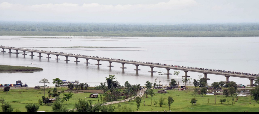
The Bangabandhu Bridge, the only bridge to span the river’s major distributary, the Jamuna, was thus opened in June 1998. Constructed at a narrow braid belt of the river, it is 4.8 km long with a platform 18.5 m wide, and it is used to carry railroad traffic as well as gas, power and telecommunication lines. Due to the variable nature of the river, the prediction of the river’s future course is crucial in planning upstream engineering to prevent flooding on the bridge.
China had built the Zangmu Dam in the upper course of the Brahmaputra River in the Tibet region and it was operationalised on 13 October 2015.
International Cooperation.
The waters of the River Brahmaputra are shared by Tibet, India, and Bangladesh. In the 1990s and 2000s, there was repeated speculation that mentioned Chinese plans to build a dam at the Great Bend, with a view to diverting the waters to the north of the country. This has been denied by the Chinese government for many years.
At the Kathmandu Workshop of Strategic Foresight Group in August 2009 on Water Security in the Himalayan Region, which brought together in a rare development leading hydrologists from the basin countries, the Chinese scientists argued that it was not feasible for China to undertake such a diversion.[29] However, on 22 April 2010, China confirmed that it was indeed building the Zangmu Dam on the Brahmaputra in Tibet,[28] but assured India that the project would not have any significant effect on the downstream flow to India.
This claim has also been reiterated by the Government of India, in an attempt to assuage domestic criticism of Chinese dam construction on the river, but is one that remains hotly debated.
Recent years have seen an intensification of grassroots opposition, especially in the state of Assam, against Chinese upstream dam building, as well as growing criticism of the Indian government for its perceived failure to respond appropriately to Chinese hydropower plans.
In a meeting of scientists at Dhaka at 2010, 25 leading experts from the basin countries issued a Dhaka Declaration on Water Security calling for the exchange of information in low-flow periods, and other means of collaboration.
Even though the 1997 UN Watercourses Convention does not prevent any of the basin countries from building a dam upstream, customary law offers some relief to the lower riparian countries. There is also the potential for China, India, and Bangladesh to cooperate on transboundary water navigation.
Significance to people.
The lives of many millions of Indian and Bangladeshi citizens are reliant on the Brahmaputra river. Its delta is home to 130 million people and 600 000 people live on the riverine islands. These people rely on the annual ‘normal’ flood to bring moisture and fresh sediments to the floodplain soils, hence providing the necessities for agricultural and marine farming. In fact, two of the three seasonal rice varieties (aus and aman) cannot survive without the floodwater.
Furthermore, the fish caught both on the floodplain during flood season and from the many floodplain ponds are the main source of protein for many rural populations.
Development. Bridges.
Under-River tunnel
Numaligarh-Gohpur under-river tunnel. The 15.6 km long tunnel, 22 22 metres below the river bed, will have 18 km approach roads to connect the NH-52 and Numaligarh on NH-37. This total ~33 km route will boot economy and strategic defence connectivity, protect Kaziranga National Park by diverting traffic away from the congested 2-lane highway through the park, shorten 223 km 6 hour long Gohpur-Numaligarh route to 35 km and 30 minutes,
This twin tube tunnel, with an under road water drainage and overhead ventilation fans, will have inter-connectivity the twin tubs for evacuation. It will be equipped with censors, CCTV, automated safety and traffic control systems. It will cost Rs 12,807 crore (US$1.7 billion in 2021).
Bangladesh.
List of bridges and Present bridges in Bangladesh
Bangabandhu Bridge (formerly Jamuna Bridge), road and rail bridge
Padma Bridge, road and rail bridge on Padma River tributary of Brahmaputra
Lalon Shah Bridge road bridge on Padma River tributary of Brahmaputra
Hardinge Bridge, rail bridge on Padma River next to Lalon Shah Bridge.
Planned bridges in Bangladesh.
Gaibandha-Bakshiganj Bridge, road and rail bridge to connect existing rail and road heads at Gaibandha-Bakshiganj on either side of the river
Siraiganj-Tangail Bridge, road and rail bridge to connect existing rail and road heads at Siraiganj-Tangail on either side of the river.
National Waterway 2 in India is 891 km long Sadiya-Dhubri stretch of Brahmaputra River in Assam.