March 16, 2022.

Two successive atmospheric rivers hit California in March 2023, bearing rain, snow, and strong winds. Hundreds of thousands of people lost power as the storm toppled trees, unleashed mudslides, and flooded streets.
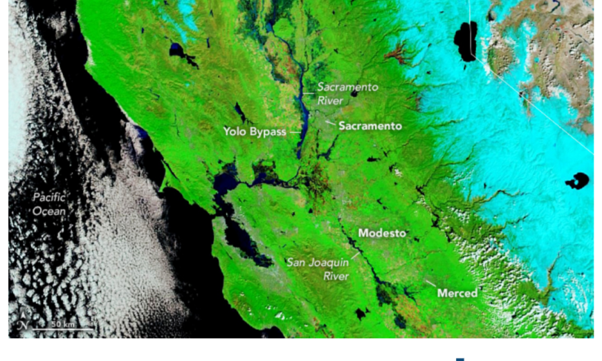
The clouds parted on March 16, allowing the Moderate Resolution Imaging Spectroradiometer (MODIS) on NASA’s Terra satellite to acquire a clear false-color image (right) of Sacramento and the San Francisco Bay Area. The false-color image on the left shows the same area on the same date in 2022. Snow appears light blue in the false-color images, water dark blue, and vegetation green.
The previous morning (March 15) the Sacramento River at Red Bluff (120 miles north of downtown Sacramento) flooded to 259 feet in elevation. That is just a foot shy of the record level set in 1997, according to the National Weather Service. Flooded agricultural fields can be seen to the north of Sacramento. Rice, tomatoes, almonds, and plums are grown in this part of California’s Central Valley. Some fields may be intentionally flooded by rice farmers who use water to manage pests.
Atmospheric rivers—vast airborne corridors of water vapor—are some of the most hazardous storm types in the middle latitudes because of how much precipitation they can produce. The latest event happened just a few days after another atmospheric river dumped 5 to 13 inches (13 to 33 centimeters) of rain over parts of Monterey County on March 10-11, 2023. The small agricultural community of Pajaro was evacuated on March 11 after floodwater breached a levee.
The storm elevated water levels on the Sacramento River above 32 feet, pushing water over the Fremont Weir and into the Yolo Bypass on March 12. Yolo Bypass was constructed in the 1920s and is part of the Sacramento River Flood Control Project designed to protect populated urban areas from floodwater. The bypass covers about 60,000 acres of farmland and wildlife areas, which has been irregularly inundated with water since its construction.
A second storm that struck on March 14 brought peak gusts of 77 miles (124 kilometers) per hour to the San Francisco airport, causing a brief halt to flights. Gusts of 60 miles per hour were recorded at the McClellan airport, just northeast of Sacramento’s downtown, according to the National Weather Service. Another inch of rain fell on Sacramento and 3 to 5 inches fell on Chico and Redding to the north. Heavy rains triggered a mudslide that hit a home in Placer County, in the northeast.
The series of atmospheric rivers also piled snow on the Sierra Nevada mountains, closing roads and leaving some residents stranded. According to the Central Sierra Snow Laboratory, a University of California Berkeley research station located in the northern Sierra Nevada, the atmospheric rivers pushed snow totals since October 1 to 55.7 feet, the third highest seen at the station at Donner Pass since it opened in 1946.
According to the National Oceanic and Atmospheric Administration (NOAA), unusually heavy precipitation in California this winter has helped ease drought conditions. Much of the state is no longer in a drought, according to a March 16 assessment from the U.S. Drought Monitor. Moderate to exceptional drought coverage across the U.S. is at its lowest since August 2020.
NASA Earth Observatory images by Lauren Dauphin, using MODIS data from NASA EOSDIS LANCE and GIBS/Worldview. Story by Emily Cassidy.
Source, NASA.

