2017 – 2021PNG
As soon as an iceberg is formed it starts to slowly dissipate. Waves chip away at its edges, air thaws it from above, and water melts it from below.
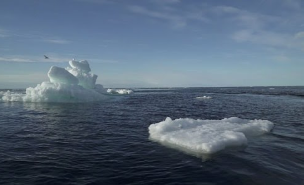
Scientists recently chronicled such death throes for one of the world’s largest-known icebergs.
In July 2017, Iceberg A-68 broke from the Larsen C Ice Shelf, along the east coast of the Antarctic Peninsula. At the time, it was the largest iceberg in the world and the sixth-largest berg in three decades of records. It measured nearly 5,800 square kilometers (2,200 square miles), or about the size of Delaware. In other words, A-68 had a lot to lose. Across three and a half years, the berg broke apart and melted, leaving its mark on the ocean environment, especially near the remote island of South Georgia.

“Icebergs are a source of cold fresh water and nutrients in the Southern Ocean,” said Anne Braakmann-Folgmann, a doctoral candidate at the University of Leeds. “However, where and how much of this is released is not very well studied and not included in ocean models yet, especially for the largest icebergs.”
Braakmann-Folgmann and colleagues set out to chart the journey of A-68A. (The new name was given to the main berg after a few small pieces broke off.) The researchers used satellite data to document changes in the iceberg’s thickness, area, volume, and mass from the time it broke from the ice shelf in July 2017 until it started to quickly disintegrate in January 2021.
The maps above show where and when the iceberg thinned as it drifted north from the Weddell Sea into the Scotia Sea. The first map (left) shows the berg’s thickness in July 2017, when it was still near the Larsen C Ice Shelf. Notice that it is thicker on its left side, where it was attached to the ice shelf, and thinner on the right side, where it was exposed to the ocean. Its total average thickness was 235 meters at the time.
As the berg drifted north, it met warmer air and water temperatures, which accelerated melting. By January 2021, when the berg closed in on South Georgia, it had thinned to an average thickness of 168 meters.
About 85 percent of an iceberg lies below the water’s surface—less than ideal for measuring its total thickness. But scientists can now estimate the thickness by measuring components of the iceberg that are above the water. Data from NASA’s Ice, Cloud, and land Elevation Satellite 2 (ICESat-2) and the European Space Agency’s CryoSat-2 (laser and radar altimeters, respectively) can indicate the distance from the satellite to the surface of the iceberg and to the surface of the sea.
The difference between these measurements is known as the iceberg’s “freeboard”—the height of the ice that rises above the water. Scientists can then convert this height into thickness by accounting for the densities of the iceberg, the snow layer on top, and the surrounding sea water.
The researchers showed that from July 2017 until January 2021, melting from the bottom of the iceberg accounted for 32 percent of its loss. Melting peaked near South Georgia, where the scientists estimated that 152 billion metric tons (152 billion cubic meters) of fresh water was added to the ocean—the equivalent of 61 million Olympic swimming pools—over the span of three months.
Scientists are still investigating the effect of all this fresh water on local ocean properties. They also want to know if the extra nutrients supplied to the ocean by the melting iceberg fostered any biological production.
Other ice losses occurred when large pieces broke away from the sides of the berg. This was especially the case when A-68A left the protective sea ice near Antarctica and moved to the north, where it was exposed to the destructive waves of the open ocean.

Thinning and fragmentation both increased as the iceberg drifted north, but fragmentation finally dominated as the iceberg disintegrated in the Northern Scotia Sea.
Courtesy, NASA.


Iceberg Formation
As global warming increases temperatures, more icebergs are calving from melting ice caps. Global warming is causing more icebergs to form, and these icebergs are melting at a faster rate than icebergs melted in the past.
As the Earth warms, the melt line moves upwards so that the glacier melts faster and faster at the bottom, shortening the glacier and reducing its mass. Ultimately, the melted water flows into streams and rivers and ends up in the oceans, contributing to accelerating sea level rise.
Specifically, since the industrial revolution, carbon dioxide and other greenhouse gas emissions have raised temperatures, even higher in the poles, and as a result, glaciers are rapidly melting, calving off into the sea and retreating on land.
Meltwater from the ice sheets and glaciers flows into the ocean, causing sea levels to rise. This can lead to flooding, habitat destruction, and other problems. Ice reflects the Sun’s energy better than than land or water. So with less ice, Earth absorbs more energy, and heats up faster.
More frequent and intense drought, storms, heat waves, rising sea levels, melting glaciers and warming oceans can directly harm animals, destroy the places they live, and wreak havoc on people’s livelihoods and communities. As climate change worsens, dangerous weather events are becoming more frequent or severe.
*
How can we prevent glaciers from melting?
Using electricity and water wisely.
To swap from energy produced by fossil fuels to clean energy sources such as wind and solar energy.
Driving less and walking more or taking the public transportation system.
Or replacing Combustion engines with hybrid engines.
*
Earlier this year, a team at the Potsdam Institute for Climate Impact Research, Germany, published research suggesting a complex link between sunlight and atmospheric CO2, leading to natural global warming. By itself, this will delay the next Ice Age by at least 50,000 years.
Rising seas endanger coastal cities and small island nations by exacerbating coastal flooding and storm surge, making dangerous weather events even more so. Glacial melt of the Greenland ice sheet is a major predictor of future sea level rise; if it melts entirely, global sea levels could rise 20 feet.
If all the ice covering Antarctica , Greenland, and in mountain glaciers around the world were to melt, sea level would rise about 70 meters (230 feet). The ocean would cover all the coastal cities. And land area would shrink significantly. But many cities, such as Denver, would survive.
Changes in the amount of sea ice can disrupt normal ocean circulation, thereby leading to changes in global climate. Even a small increase in temperature can lead to greater warming over time, making the polar regions the most sensitive areas to climate change on Earth.
The top of the world is turning from white to blue in summer as the ice that has long covered the north polar seas melts away. This monumental change is triggering a cascade of effects that will amplify global warming and could destabilize the global climate system.
.

Some of the most intense basal melting is happening at the ice shelves around the Thwaites Glacier and the Pine Island Glacier in West Antarctica. For 60 years, the ice front around the Pine Island Glacier stood in place, but between 2015 and 2020, its northern region suddenly retreated more than 30 kilometers.