April 6, 2023.
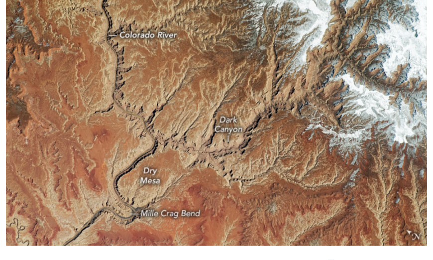
Deep, meandering canyons cut through the Colorado Plateau in southeastern Utah in this photograph, taken by an astronaut on the International Space Station on April 6, 2023. These canyons, known as the Dark Canyon complex, have distinctive geology, ecology, and archeology. They are some of the only intact protected canyons in the United States.
This rugged and remote landscape has been shaped by erosion. Over thousands of years, the Colorado River and smaller tributaries have eroded winding, steep-walled canyons into the sedimentary rock. Dark Canyon—one of seven canyons within the complex—cuts diagonally across the photo. Within this canyon, sandstone walls tower up to 3,000 feet (900 meters), shading visitors from morning and afternoon sun—hence its name. The canyon’s steep walls expose roughly 250 million years of geologic history and contain deposits from the Permian period. Cockleshell and crinoid stem fossils have been found in the area.
The Colorado River flows in from Canyonlands National Park, located just 6 miles (10 kilometers) northeast of this view. The confluence of the Green and Colorado rivers in Canyonlands creates powerful rapids down river. This segment of the river—part of Glen Canyon National Recreation Area—is known as Cataract Canyon and is notorious for its hazardous whitewater rafting conditions.
Springs, hanging gardens, riparian areas, and mesas provide habitat for a wide range of wildlife around the Dark Canyon complex. Golden eagles, peregrine falcons, and the Mexican spotted owl have been observed in the complex. Dark Canyon itself extends east beyond the photo into a designated wilderness area in the Manti-La Sal National Forest.
The Dark Canyon complex is part of Bears Ears National Monument, which contains many cultural and archaeological sites. According to a presidential proclamation issued October 2021, Bears Ears is sacred land to several Tribal Nations and Pueblos.
Although Ancestral Puebloan occupation seems to have been somewhat sparser in Dark Canyon compared to canyons farther south, cliff dwellings, petroglyphs, and lithic scatters do exist within this area.
Astronaut photograph ISS069-E-001017 was acquired on April 6, 2023, with a Nikon D5 digital camera using an 400 millimeter lens and is provided by the ISS Crew Earth Observations Facility and the Earth Science and Remote Sensing Unit, Johnson Space Center. The image was taken by a member of the Expedition 69 crew. The image has been cropped and enhanced to improve contrast, and lens artifacts have been removed.
The International Space Station Program supports the laboratory as part of the ISS National Lab to help astronauts take pictures of Earth that will be of the greatest value to scientists and the public, and to make those images freely available on the Internet. Additional images taken by astronauts and cosmonauts can be viewed at the NASA/JSC Gateway to Astronaut Photography of Earth. Story by Emily Cassidy.
Source, NASA.

