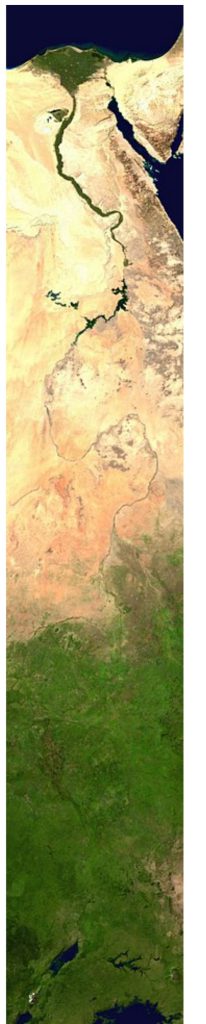
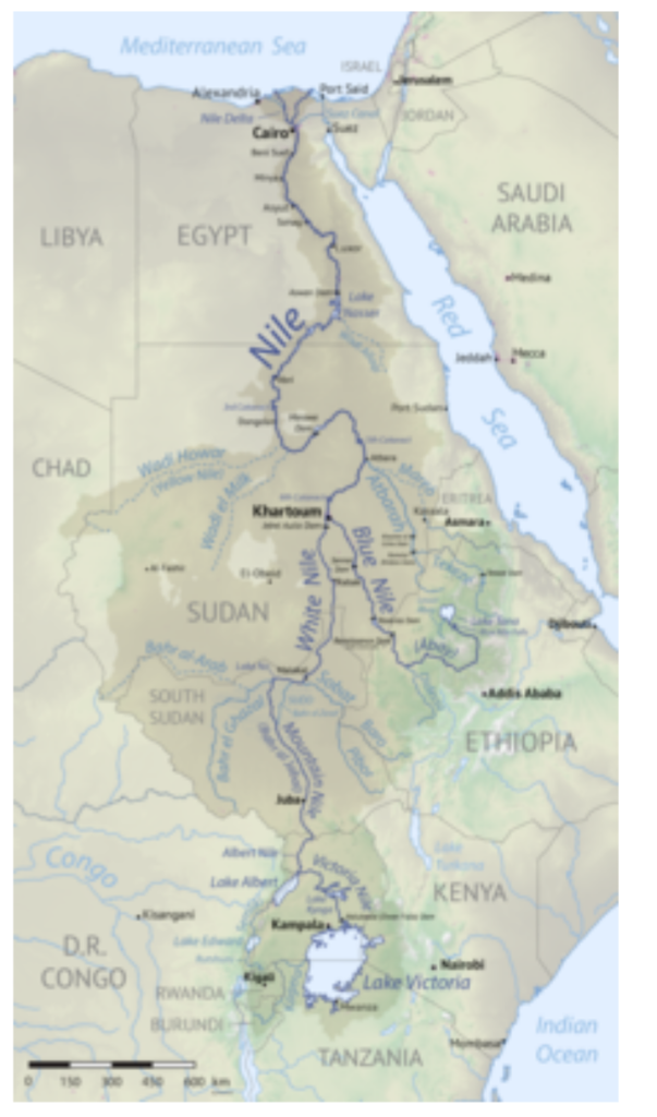
The Nile is a major north-flowing river in northeastern Africa. It flows into the Mediterranean Sea. The Nile is the longest river in Africa and has historically been considered the longest river in the world, though this has been contested by research suggesting that the Amazon River is slightly longer.
The Nile is a major north-flowing river in northeastern Africa. It flows into the Mediterranean Sea. The Nile is the longest river in Africa and has historically been considered the longest river in the world, though this has been contested by research suggesting that the Amazon River is slightly longer. Of the world’s major rivers, the Nile is one of the smallest, as measured by annual flow in cubic metres of water. About 6,650 km (4,130 mi)[a] long, its drainage basin covers eleven countries: the Democratic Republic of the Congo, Tanzania, Burundi, Rwanda,
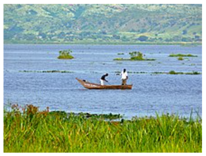
Uganda, Kenya, Ethiopia, Eritrea, South Sudan, Republic of the Sudan, and Egypt.[9] In particular, the Nile is the primary water source of Egypt, Sudan and South Sudan. Additionally, the Nile is an important economic river, supporting agriculture and fishing.
Location,
Countries,
Egypt, Sudan, South Sudan, Ethiopia, Uganda, Democratic Republic of the Congo, Kenya, Tanzania, Rwanda, Burundi.
Major cities, Jinja, Juba, Khartoum, Cairo.
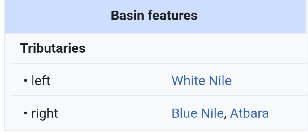
The Nile has two major tributaries – the White Nile and the Blue Nile. The White Nile is traditionally considered to be the headwaters stream.
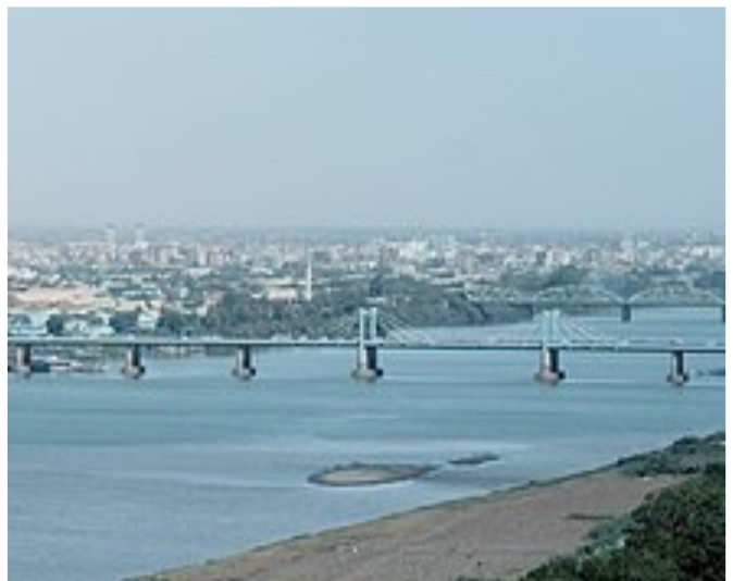
However, the Blue Nile is the source of most of the water of the Nile downstream, containing 80% of the water and silt. The White Nile is longer and rises in the Great Lakes region. It begins at Lake Victoria and flows through Uganda and South Sudan. The Blue Nile begins at Lake Tana in Ethiopia and flows into Sudan from the southeast. The two rivers meet at the Sudanese capital of Khartoum.
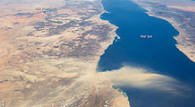
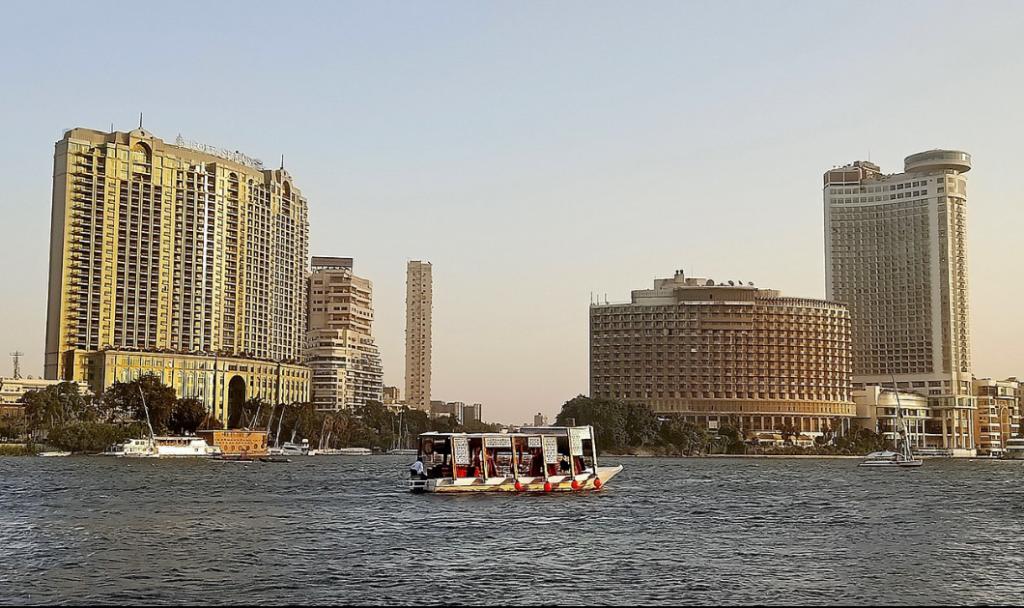
The northern section of the river flows north almost entirely through the Nubian Desert to Cairo and its large delta, and the river flows into the Mediterranean Sea at Alexandria. Egyptian civilization and Sudanese kingdoms have depended on the river and its annual flooding since ancient times. Most of the population and cities of Egypt lie along those parts of the Nile valley north of Aswan Dam. Nearly all the cultural and historical sites of Ancient Egypt developed and are found along river banks. The Nile is, with the Rhône and Po, one of the three Mediterranean rivers with the largest water discharge.
Etymology.
The standard English names “White Nile” and “Blue Nile” refer to the river’s source, derived from Arabic names formerly applied to only the Sudanese stretches that meet at Khartoum.
In the ancient Egyptian language, the Nile is called Ḥ’pī (Hapy) or Iteru, meaning “river”. In Coptic, the word ⲫⲓⲁⲣⲟ, pronounced piaro (Sahidic) or phiaro (Bohairic), means “the river” (lit. p(h).iar-o “the.canal-great”), and comes from the same ancient name. In Nobiin the river is called Áman Dawū, meaning “the great water”. In Luganda the river is called Kiira or Kiyira. In Runyoro its called Kihiira. In Egyptian Arabic, the Nile is called en-Nīl, while in Standard Arabic it is called an-Nīl. In Biblical Hebrew, it is הַיְאוֹר, Ha-Ye’or or הַשִׁיחוֹר, Ha-Shiḥor.
The English name Nile and the Arabic names en-Nîl and an-Nîl both derive from the Latin Nilus and the Ancient Greek Νεῖλος. Beyond that, however, the etymology is disputed. Homer called the river Αἴγυπτος, Aiguptos, but in subsequent periods, Greek authors referred to its lower course as Neilos; this term became generalised for the entire river system. Thus, the name may derive from Ancient Egyptian expression nꜣ rꜣw-ḥꜣw(t) (lit. ‘the mouths of the front parts’), which referred specifically to the branches of the Nile transversing the Delta, and would have been pronounced ni-lo-he in the area around Memphis in the 8th century BCE. Hesiod at his Theogony refers to Nilus (Νεῖλος) as one of the Potamoi (river gods), son of Oceanus and Tethys.
Another derivation of Nile might be related to the term Nil (Sanskrit: नील, romanized: nila; Egyptian Arabic: نيلة), which refers to Indigofera tinctoria, one of the original sources of indigo dye. Another may be Nymphaea caerulea, known as “The Sacred Blue Lily of the Nile”, which was found scattered over Tutankhamun’s corpse when it was excavated in 1922. Another possible etymology derives from the Semitic term Nahal, meaning “river”. Old Libyan has the term lilu, meaning water (in modern Berber ilel ⵉⵍⴻⵍ means sea).
COURSES.
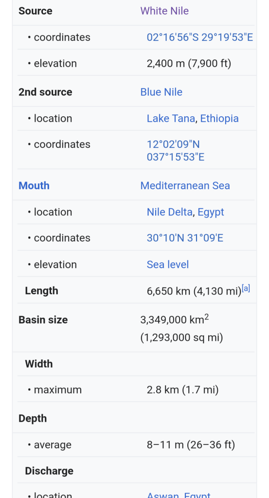
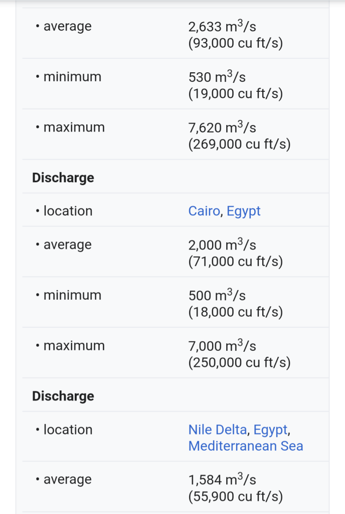
With a total length of about 6,650 km (4,130 mi) between the region of Lake Victoria and the Mediterranean Sea, the Nile is among the longest rivers on Earth. The drainage basin of the Nile covers 3,254,555 square kilometers (1,256,591 sq mi), about 10% of the area of Africa. Compared to other major rivers, though, the Nile carries little water (5% of the Congo River, for example).
The Nile basin is complex, and because of this, the discharge at any given point along the main stem depends on many factors including weather, diversions, evaporation and evapotranspiration, and groundwater flow.
Upstream from Khartoum (to the south), the river is known as the White Nile, a term also used in a limited sense to describe the section between Lake No and Khartoum. At Khartoum, the river is joined by the Blue Nile. The White Nile starts in equatorial East Africa, and the Blue Nile begins in Ethiopia. Both branches are on the western flanks of the East African Rift.
SOURCES.
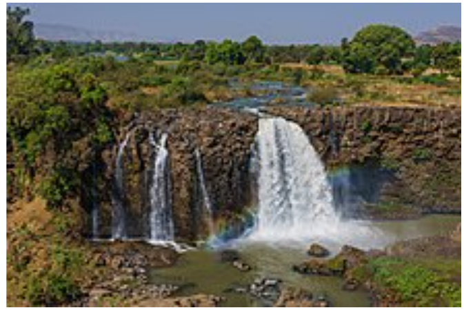
The source of the Blue Nile is Lake Tana in the Gish Abay region in the Ethiopian Highlands.
The source of the White Nile, even after centuries of exploration, remains in dispute. The most remote source that is indisputably a source for the White Nile is the Kagera River; however, the Kagera has tributaries that are in contention for the farthest source of the White Nile. Two start in Burundi: the Ruvyironza River (also known as the Luvironza) and the Rurubu River.
In addition, in 2010, an exploration party in Rwanda went to a place described as the source of the Rukarara tributary, and by hacking a path up steep jungle-choked mountain slopes in the Nyungwe Forest found (in the dry season) an appreciable incoming surface flow for many kilometres upstream, and found a new source, giving the Nile a length of 6,758 km (4,199 mi).
IN UGANDA.
The White Nile leaves Lake Victoria at Ripon Falls near Jinja, Uganda, as the “Victoria Nile.” It flows north for some 130 kilometers (81 mi) to Lake Kyoga. The last part of the approximately 200 kilometers (120 mi) river section starts from the western shores of the lake and flows at first to the west until just south of Masindi Port, where the river turns north, then makes a great half circle to the east and north to Karuma Falls. For the remaining part, it flows westerly through the Murchison Falls until it reaches the northern shores of Lake Albert where it forms a significant river delta. Lake Albert is on the border of the Democratic Republic of the Congo, but the Nile is not a border river at this point. After leaving Lake Albert, the river continues north through Uganda and is known as the Albert Nile.
In South Sudan.
The White Nile flows into South Sudan just south of Nimule, where it is known as the Bahr al Jabal (“Mountain River”. Just south of the town is the confluence with the Achwa River.
The Bahr al Ghazal, 716 kilometers (445 mi) long, joins the Bahr al Jabal at a small lagoon called Lake No, after which the Nile becomes known as the Bahr al Abyad, or the White Nile, from the whitish clay suspended in its waters. When the Nile floods it leaves a rich silty deposit which fertilizes the soil. The Nile no longer floods in Egypt since the completion of the Aswan Dam in 1970. An anabranch river, the Bahr el Zeraf, flows out of the Nile’s Bahr al Jabal section and rejoins the White Nile.
The flow rate of the Bahr al Jabal at Mongalla is almost constant throughout the year and averages 1,048 m3/s (37,000 cu ft/s). After Mongalla, the Bahr Al Jabal enters the enormous swamps of the Sudd region. More than half of the Nile’s water is lost in this swamp to evaporation and transpiration. The average flow rate of the White Nile at the tails of the swamps is about 510 m3/s (18,000 cu ft/s). From here it meets with the Sobat River at Malakal. On an annual basis, the White Nile upstream of Malakal contributes about 15% of the total outflow of the Nile.
The average flow of the White Nile at Lake Kawaki Malakal, just below the Sobat River, is 924 m3/s (32,600 cu ft/s); the peak flow is approximately 1,218 m3/s (43,000 cu ft/s) in October and minimum flow is about 609 m3/s (21,500 cu ft/s) in April. This fluctuation is caused by the substantial variation in the flow of the Sobat, which has a minimum flow of about 99 m3/s (3,500 cu ft/s) in March and a peak flow of over 680 m3/s (24,000 cu ft/s) in October.[37] During the dry season (January to June) the White Nile contributes between 70% and 90% of the total discharge from the Nile.
In The South Sudan.
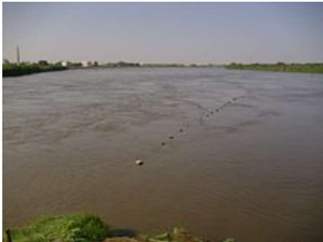
Below Renk, the White Nile enters Sudan, it flows north to Khartoum and meets the Blue Nile.
The course of the Nile in Sudan is distinctive. It flows over six groups of cataracts, from the sixth at Sabaloka just north of Khartoum northward to Abu Hamad. The tectonic uplift of the Nubian Swell diverts the river south-west for over 300 km, following the structure of the Central African Shear Zone embracing the Bayuda Desert. At Al Dabbah it resumes its northward course towards the first cataract at Aswan forming the ‘S’-shaped Great Bend of the Nile mentioned by Eratosthenes.[39]
In the north of Sudan, the river enters Lake Nasser (known in Sudan as Lake Nubia), the larger part of which is in Egypt.
In Egypt.
Below the Aswan Dam, at the northern limit of Lake Nasser, the Nile resumes its historic course. North of Cairo, the Nile splits into two branches (or distributaries) that feed the Mediterranean: the Rosetta Branch to the west and the Damietta to the east, forming the Nile Delta.
The Nile proper, rises from Lake Victoria, the second largest freshwater lake in the world, which has an area of more than 26,800 square miles and forms a huge but shallow lake.
Annotated bibliography
The following is an annotated bibliography of key written documents for the Western exploration of the Nile.
17th century
Historia da Ethiopia, Pedro Páez (aka Pero Pais), Portugal, 1620
A Jesuit missionary who was sent from Goa to Ethiopia in 1589 and remained in the area until his death in 1622. Credited with being the first European to view the source of the Blue Nile which he describes in this volume.
Voyage historique d’Abissinie, Jerónimo Lobo (aka Girolamo Lobo), Piero Matini, Firenze; 1693
One of the most important and earliest sources on Ethiopia and the Nile. Jerónimo Lobo (1595–1687), a Jesuit priest, stayed in Ethiopia, mostly in Tigre, for 9 years and travelled to Lake Tana and the Blue Nile, reaching the province of Damot. When the Jesuits were expelled from the country, he too had to leave and did so via Massaua and Suakin. “He was the best expert on Ethiopian matters. After Pais, Lobo is the second European to describe the sources of the Blue Nile and he did so more exactly than Bruce” (transl. from Henze).
SourceOwn work.
Author, A.Savin.
Date, 21 October 2020, 16:29:21
Source, Own work. Author, Faris knight.
Source, Own work.
Author, Marc Ryckaert (MJJR).
Source, Own work. Author, Mohamed Amarochan.
Modern achievements and exploration.
White Nile
In 1951, American John Goddard together with two French explorers became the first to successfully navigate the entire Nile from its source in Burundi at the potential headsprings of the Kagera River in Burundi to its mouth on the Mediterranean Sea, a journey of approximately 6,800 km (4,200 mi).
Their 9-month journey is described in the book Kayaks down the Nile.
The White Nile Expedition, led by South African national Hendrik Coetzee, navigated the White Nile’s entire length of approximately 3,700 kilometres (2,300 mi).
The expedition began at the White Nile’s beginning at Lake Victoria in Uganda, on 17 January 2004 and arrived at the Mediterranean in Rosetta, four and a half months later.
Blue Nile
The Blue Nile Expedition, led by geologist Pasquale Scaturro and his partner, kayaker and documentary filmmaker Gordon Brown became the first known people to descend the entire Blue Nile, from Lake Tana in Ethiopia to the beaches of Alexandria on the Mediterranean. Their approximately 5,230-kilometre (3,250 mi) journey took 114 days, from 25 December 2003 to 28 April 2004.
Though their expedition included others, Brown and Scaturro were the only ones to complete the entire journey. Although they descended whitewater manually, the team used outboard motors for much of their journey.
On 29 January 2005, Canadian Les Jickling and New Zealander Mark Tanner completed the first human powered transit of Ethiopia’s Blue Nile. Their journey of over 5,000 kilometres (3,100 mi) took five months. They recount that they paddled through two war zones, regions notorious for bandits, and were arrested at gunpoint.
Hydro power plants along the Nile river (from OpenStreetMap).
Map created from OpenStreetMap with Overpass
Date, 6 October, 2020.
Source, Own work.
Author, Erik Zachte.
.
Source, Wikipedia mainly, under CC BY-SA 3.0 unless otherwise noted.