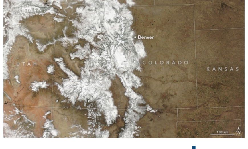
March 19, 2024.
As winter turned to spring, a mid-March storm dropped several feet of snow on Colorado. Clear skies on March 19, 2024, allowed the MODIS (Moderate Resolution Imaging Spectroradiometer) instrument on NASA’s Terra satellite to capture this image of snow covering the Rocky Mountains.
A potent low-pressure system swept through the state on March 13 and 14, bringing 10 to 20 inches (25 to 50 centimeters) to the Denver and Boulder metropolitan areas. Some of the highest snowfall totals were recorded on March 14 in the high elevations of the southern Rocky Mountains, according to NOAA’s daily snowfall observations. In Nederland, 28 miles northwest of Denver, 53 inches of snow was recorded after the storm.
The snowstorm caused power outages, road closures, and 800 canceled flights at Denver International Airport. According to news reports, Interstate 70, which runs through the Rockies, was closed for much of March 14 due to safety concerns.
Although Colorado’s winter got off to a slow start, the storm pushed snowpack levels above normal across the state. As of March 19, the snowpack statewide was at 109 percent of the 1991 to 2020 average. March and April snowstorms are common in the state. Ten of Denver’s top 20 largest snowstorms since 1882 have occurred in either March or April, according to the National Weather Service.
While Colorado’s snowpack is faring well, other parts of the U.S. are experiencing a significant snow drought, especially the Midwest and Northern Plains regions. The 2023-2024 winter was the warmest in NASA’s record, which meant more precipitation fell as rain than snow. According to the National Weather Service, only 17 percent of the contiguous U.S. was covered by snow on February 23, the smallest area for that date in records dating back to 2004. The average coverage for the date over the past 20 years is about 37 percent.
NASA Earth Observatory image by Wanmei Liang, using MODIS data from NASA EOSDIS LANCE and GIBS/Worldview. Story by Emily Cassidy.
Source, NASA.

