May 2, 2024.

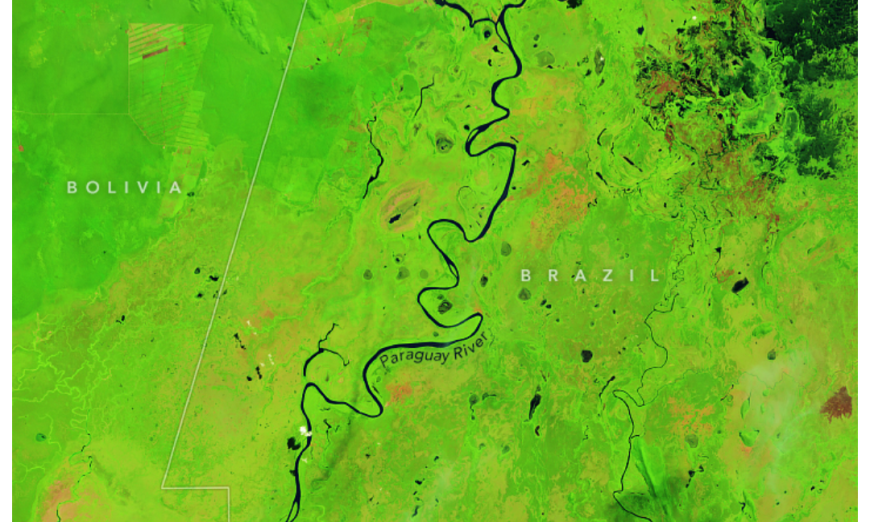
Unusually early and intense blazes spread over Brazil’s Pantanal wetlands in late May and early June 2024. Lack of wet-season rainfall dried vegetation and helped the wildfires spread well before the region’s fire season typically begins.
The Pantanal, a vast floodplain in South America, is a mosaic of lakes, flooded grasslands, shrublands, and forests that covers an area as large as West Virginia. It is home to thousands of species, including jaguars, giant river otters, hyacinth macaws, and giant armadillos.
Fire season in southern Brazil usually starts in July and peaks in August and September. In June 2024, Brazil’s National Institute for Space Research (INPE) observed unusually intense fire activity in the Pantanal. Using data from the MODIS (Moderate Resolution Imaging Spectroradiometer) instrument on NASA’s Aqua satellite, INPE detected 549 active fires as of June 11, which is more fire detections than any June in INPE’s record, going back to 1998. These individual fire detections correspond to at least 6 large ongoing fire events (>200 square kilometers), based on data from the SERVIR Amazon Dashboard.
The images above show the Pantanal wetlands in western Mato Grosso do Sul on June 11 (right) and May 2 (left). The false-color images emphasize the burn scars (brown) from several of the fires. Unburned vegetation is green. Near- and short-wave infrared bands help penetrate some of the smoke to reveal the hot spots associated with active fires, which appear orange. They were acquired by the OLI (Operational Land Imager) on Landsat 8 and the OLI-2 on Landsat 9, respectively. According to the Federal University of Rio de Janeiro’s satellite monitoring program, over 3,500 square kilometers (1,350 square miles) of the Pantanal have burned so far in 2024.
Smoke from the wildfires can be seen billowing toward Corumbá, in Mato Grosso do Sul, in the image below. The natural-color image was acquired by MODIS aboard NASA’s Aqua satellite on June 9, 2024.

The 2023–2024 El Niño brought drier and hotter conditions to the Pantanal and nearby Amazon rainforest. From December 2023 to May 2024, the Pantanal experienced irregular rains and an overall deficit of precipitation, according to a report from Brazil’s National Center for Natural Disaster Monitoring and Alerts. By the end of May 2024, almost the entire Pantanal region was classified as experiencing extreme drought, the second-highest classification of drought intensity on the Integrated Drought Index.
“These rainfall patterns are consistent with the long tail of El Niño,” said Douglas Morton, an Earth system scientist in the Biospheric Sciences Laboratory at NASA’s Goddard Space Flight Center. “The southern Amazon and Pantanal biomes received less rainfall during the wet season, leaving the region predisposed to a longer and stronger dry season with elevated fire risk.”
Every year, Morton and a team of scientists use satellite data, such as sea surface temperatures and precipitation, to forecast the fire season severity in the Amazon regions of Brazil, Bolivia, and Peru. This year, El Niño, as well as a warmer-than-usual sea surface in the northern Atlantic Ocean, have been pulling rainfall away from the Amazon and surrounding biomes. This has exacerbated already parched conditions in the states of Mato Grosso do Sul and neighboring Mato Grosso. “From October through April, that region received a meter less rain than expected,” Morton said. “Fire risk in Mato Grosso this year is as high as it has ever been since the start of the MODIS data record in 2000.”
So far in 2024, the intensity of fires in Pantanal has been higher than the same early-season period in 2020. That year, catastrophic fires burned 39,000 square kilometers (15,000 square miles), or one-third of the whole biome.
NASA Earth Observatory images by Michala Garrison, using Landsat data from the U.S. Geological Survey and MODIS data from NASA EOSDIS LANCE and GIBS/Worldview. Story by Emily Cassidy.
Source, NASA.

