July 27, 2024 July 27, 2024
The Park Fire in Northern California more than doubled in area in a matter of days in late July 2024. It quickly became the state’s seventh-largest wildland fire on record, and as of July 29, it was the largest active fire in the United States.
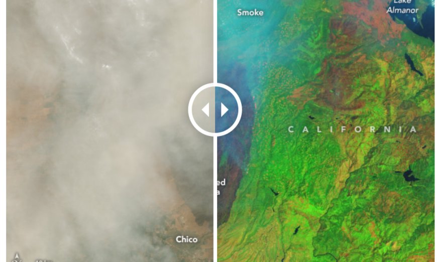
The OLI-2 (Operational Land Imager-2) on Landsat 9 captured these images of the Park Fire on July 27. In the natural-color scene (left), widespread smoke largely obscures the fire’s mark on the land below. The burned area is evident in the false-color image (right) showing shortwave infrared, near infrared, and visible light (OLI bands 6-5-3). This band combination makes it easier to identify unburned vegetated areas (green) and the recently burned landscape (brown). Thicker areas of the smoke plume appear light blue.
The Park Fire ignited around 3 p.m. local time on July 24 near Chico, California, and spread rapidly as it consumed dry grass and brush. By the morning of July 26, it had burned 165,000 acres. The next day, when these images were acquired, the burned area had ballooned to 307,000 acres—an area larger than the city of Los Angeles—according to Cal Fire. Record heat, high winds, and abundant dry fuel contributed to the extreme fire behavior and rapid expansion, experts told news sources.
Periods of cooler temperatures starting the evening of July 27 moderated the fire’s growth and allowed crews to combat the flames. Cal Fire reported that the fire had grown to approximately 370,000 acres on July 29, with 12 percent containment. The blazes prompted evacuation orders in four counties and the closure of public lands, including Lassen Volcanic National Park.
NASA Earth Observatory images by Wanmei Liang, using Landsat data from the U.S. Geological Survey. Story by Lindsey Doermann.
Source, NASA.
.

